Northern Exposure: Tel Abel Beth Maacah after Six Seasons of Excavation
JANUARY 2019 | Vol. 7.1
By Robert Mullins, Naama Yahalom-Mack, and Nava Panitz-Cohen
This research was supported by the Israel Science Foundation (Grant No. 859/17).
The name may be difficult to pronounce and its location far from the large population centers of modern Israel, but the finds from this prominent 35-acre mound are already changing how we view the Iron Age in northern Israel.
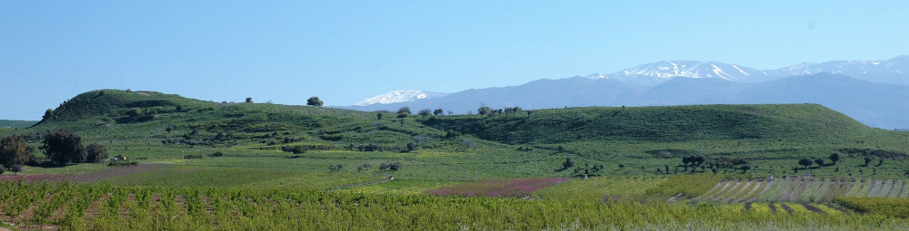
Tel Abel Beth Maacah looking northeast. Mt. Hermon in the background.Photography by John Monson.
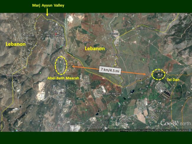
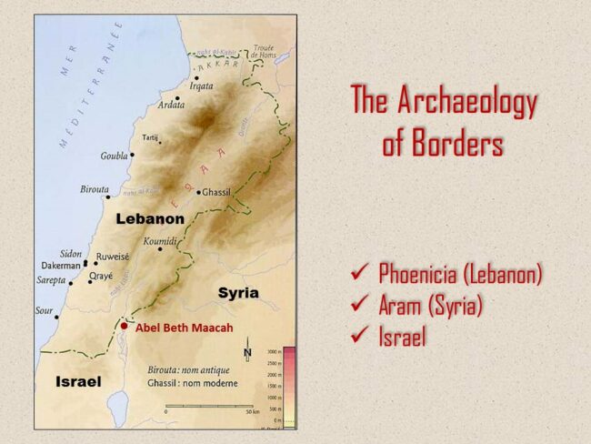
As we pointed out in our 2013 article inAncient Near East Today, this ancient city on the Lebanese border some seven kilometers (4.5 miles) west northwest of Tel Dan straddles three ancient polities: Phoenicia, Aram/Syria, and Israel.
Abel Beth Maacah in relation to Tel Dan. Prepared by Robert Mullins
Abel Beth Maacah sits at the intersection of three ancient and modern countries. Prepared by Robert Mullins.
While that article focused on Abel’s archaeological potential, here, we would like to highlight what we have learned from this once neglected site.
Robert Mullins, Naama Yahalom-Mack, and Nava Panitz-Cohen co-direct the project on behalf of Azusa Pacific University and the Hebrew University of Jerusalem. As former students of Amihai Mazar, we regard this project as a continuation of his methodology, vision, and collaborative spirit.
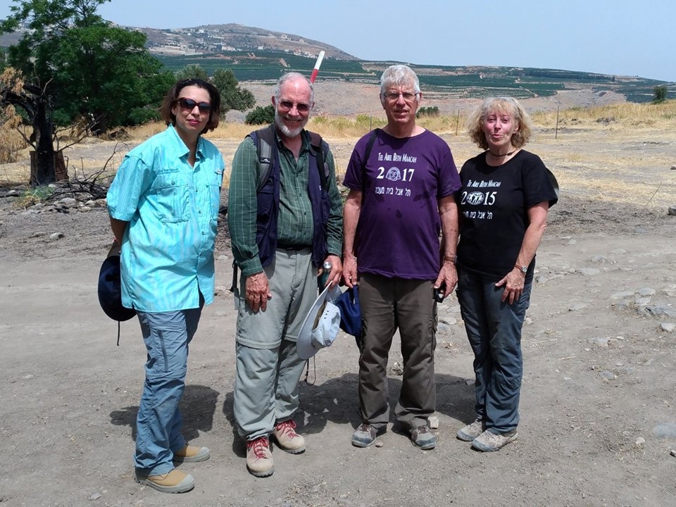
The three co-directors with their mentor. From left to right: Naama Yahalom-Mack, Robert Mullins, Ami Mazar, and Nava Panitz-Cohen
The Bronze Age
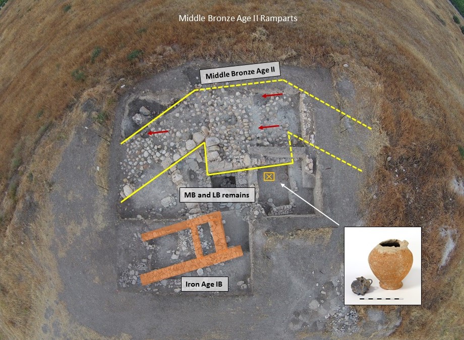
The results of the 2012 survey pointed to significant Early Bronze II-III (ca. 3000-2700 BCE) remains not yet excavated. By contrast, we exposed the remains of a Middle Bronze II-style fortification system in the upper city in Area B and below topsoil at the southern tip of the lower city in Area F; the latter features a prominent tower and stone-capped rampart. Middle Bronze and Late Bronze structures abut the inside of the fortification.
View of Area F at the southern tip of the lower city. Middle and Late Bronze Age structures about the northern face of the MB fortifications. This includes the LBIIB floor that produced the jug containing a silver hoard. Iron II pits were dug into the fortifications after they went out of use (see the arrows) and part of an Iron I structure lies further north. Aerial photo by Robert Mullins. Photo of jug with hoard by Gabi Laron
Thus, Abel remained fortified during the Late Bronze Age (ca. 1550-1200 BCE) when many cities in Canaan were not.
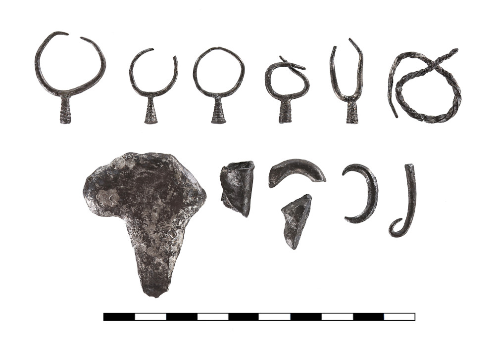
Finds from these periods include a floor from the 13th century BCE abutting the tower that produced a small jug containing a silver hoard whose 12 items were evidently used for monetary exchange (Figure 7). Late Bronze IIB remains also appear in Area A, though we have only begun to expose them.
The extracted silver hoard after cleaning. Photography by Gabi Laron.Conservation by Mimi Lavi, The Hebrew University of Jerusalem
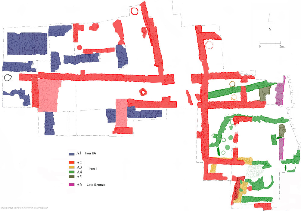
The eastern part of Area A looking west. Photography by Robert Mullins.Fig. 10–Plan of Area A showing all six phases. Plan by Ruhama Bonfil. Photographed by Robert Mullins.
Though Middle Bronze remains are present in the upper and lower cities, the Late Bronze Age appears to be limited to the latter. Notably, we have not yet detected any traces of destruction in those areas where we have exposed the Late Bronze to the Iron Age transition, as opposed to the violent termination suffered at this time by our neighbor Hazor.
The Iron Age In The Lower City
The city’s fortifications appear to have gone out of use by Iron Age I (ca. 1200 BCE) as evident by the Iron I pits dug into the Area F fortifications (see Figure 7 and the red arrows.) To our knowledge, no new fortification system was built in the lower city throughout the remainder of the site’s history. This conflicts with the biblical account of the city’s siege in 2 Samuel 20:15, though the presence or absence of fortifications in the upper city remains a mystery.
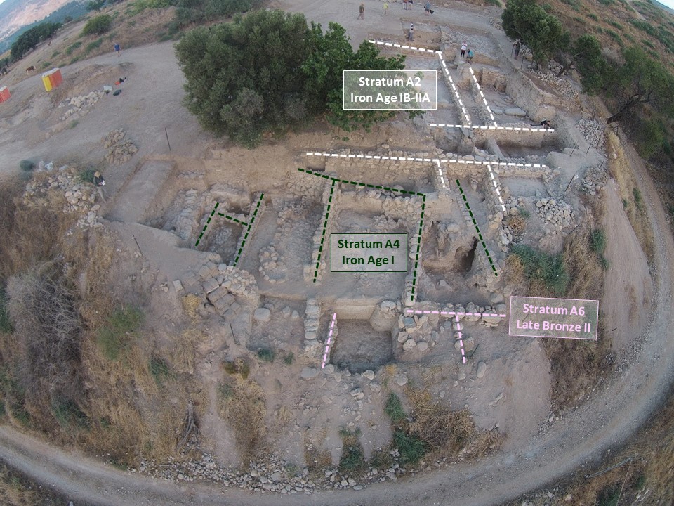
Area A preserves the best sequence of Iron Age remains. Of the six phases exposed so far, we will stress two from Iron Age I (Strata A4 and A2) and one from Iron Age IIA (Stratum A1).
Plan of Area A showing all six phases. Plan by Ruhama Bonfil
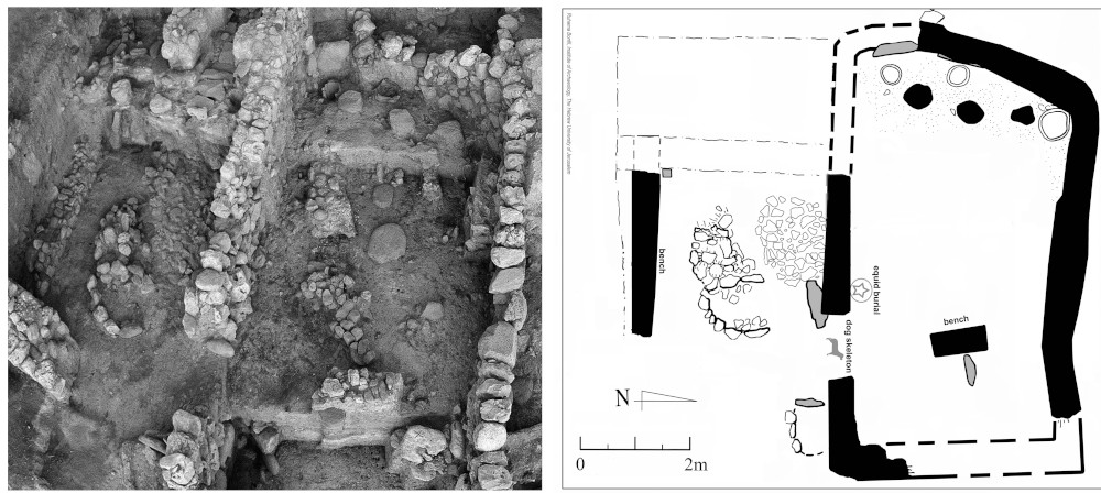
Stratum A4 (see Figure 11, the green walls) consists of a two-part shrine whose southern room features a small platform abutting U-shaped stones facing a standing stone next to a doorway leading to the northern space.
Photo and Plan of Stratum A4 featuring the smaller southern space (left) and the larger northern space (right). Photography by Robert Mullins and plan by RuhamaBonfil
The room was filled with restorable vessels and a complete deer antler buried in many cubic feet of destruction debris. 14Carbon dates point to its destruction in the 11th century BCE. In the northern space was another standing stone near a bench. The small clay fragment of a bull lay nearby and a pit by the doorway into the southern room contained an equid burial. At the western end were two ovens and a storage-jar base fronted by three flat-topped stones, possibly work or offering tables. One notable architectural feature was the curved wall in the northeast corner.
Stratum A2 (see Figure 11, the red walls) is an expansive architectural complex comprising a courtyard building on the east and a unit with industrial, administrative, and cultic functions on the west. A corridor lined with stone buttresses passes in-between them. A stacked stone altar demarcated by a low wall is nestled by one buttress. In the western unit, a pot bellows embedded into the floor and in secondary use contained evidence for bronze and iron metalworking. A hall with cultic features at the northern end of the western wing might relate to the nearby metalworking activity or other endeavors.
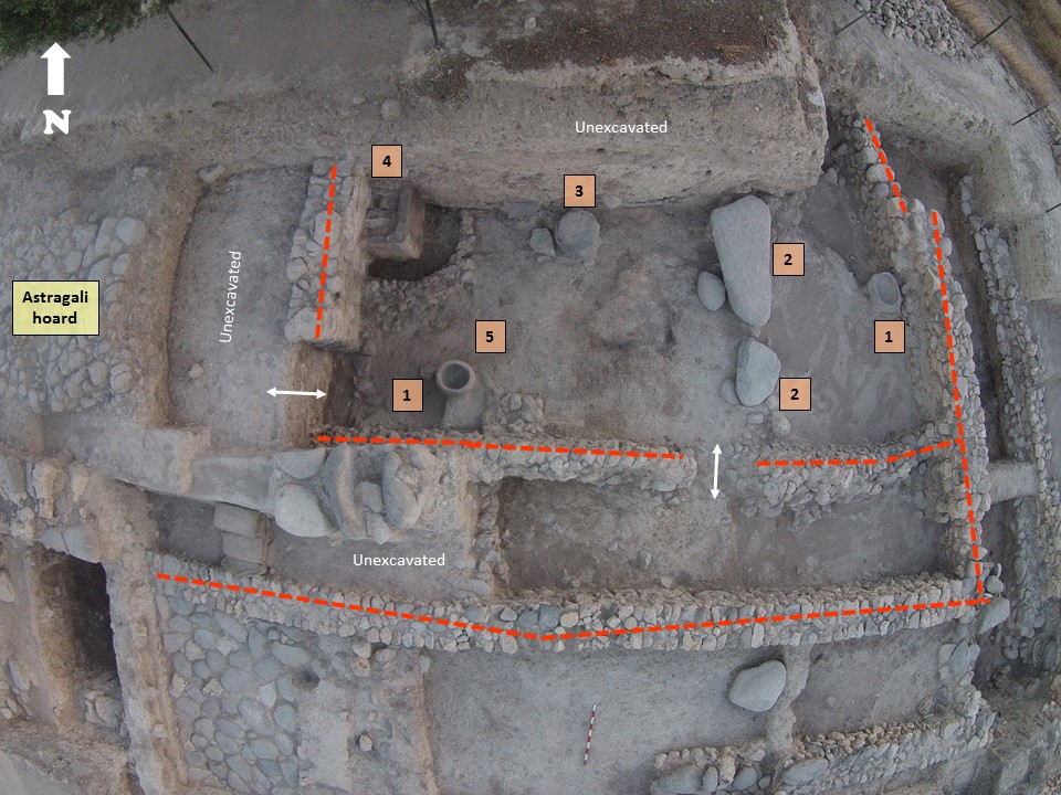
Presumed cultic space at the northern end of the Stratum A2 administrative-industrial complex. The larger unit is to the north and a narrower space to the south.These units are not yet fully excavated. Photography by Robert Mullins
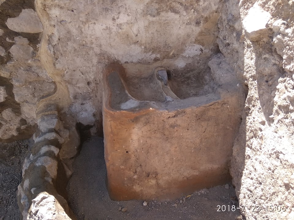
The hall contains two stone basins at either end (1), two stones on their backs that may have once sat horizontally (2), stacked circular stones of an altar or offering table (3), and a plastered installation (4) equipped with two basins and demarcated by a low wall.
Plastered installation after conservation, featuring two plastered basins and enclosed by a low wall of fieldstones. Photography by Nisan Ben-Natan.
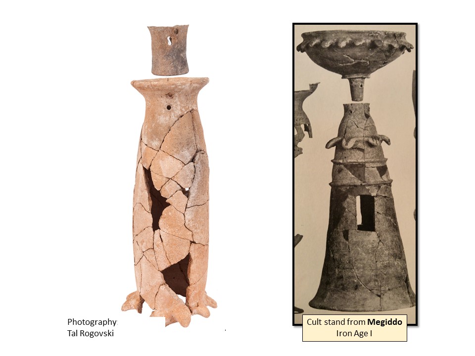
Smashed Tyrian (wavy-band) pithoi typical to the Phoenician coast lay near the basin, as well as a cylindrical cult stand with drooping petals near the base (5). Inside the mouth was the base of a large bowl or funnel, similar to one from Iron Age IB Megiddo.
Restored cult stand found nearby the plastered installation. Here, the standish compared to one from Megiddo. Photography by Tal Rogovski.
The ceramic corpus is typical to the 11th century BCE. 14Carbon places the violent destruction of this hall sometime in the 10th century BCE.
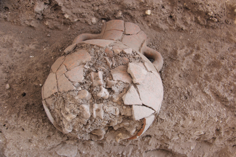
Stratum A1 (see Figure 11, the blue walls) is a large public structure dating to the late 10th-9th centuries BCE, but it lacks a coherent plan due to the effects of farming and erosion. The most significant find was an extensive stone floor on top of which sat a small podium, and on it, an amphora containing some 425 astragali (animal knucklebones).
Iron Age IIA amphora containing hoard of astragali. Photography by Robert Mullins.
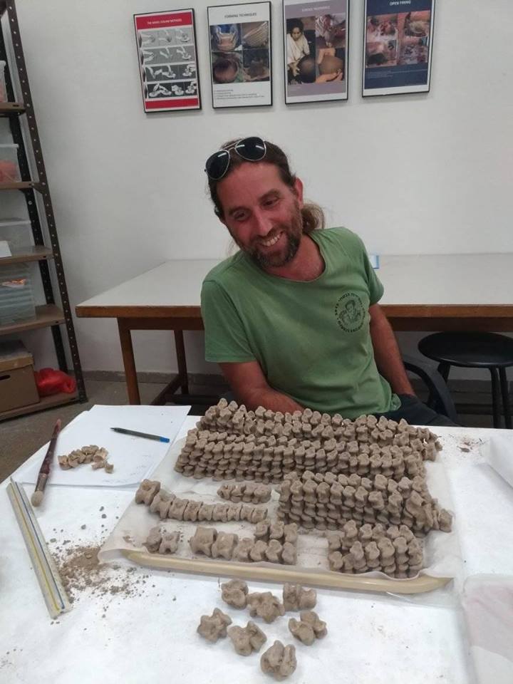
While such astragali were commonly used as gaming pieces, they were also used for divination, especially when found in such a large hoard.
Area B supervisor and faunal analyst, Ariel Shatil, admires the 425 astragali sheep, goat, gazelle, and deer. Photography by Nava Panitz-Cohen.
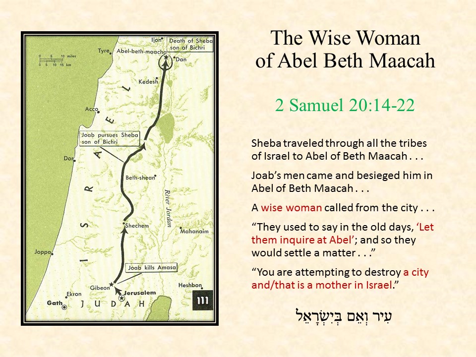
What stands out most to us about the sequence of Iron I strata in Area A is the apparent continuity of cult. To what degree might the words of the “wise woman” in 2 Samuel 20:18-19 echo her role as an oracle or prophet, and the city’s function as a place of arbitration?
Excerpts from the biblical account of Sheva ben Bichri escape to Abel Beth Maacah. Prepared by Robert Mullins.
The Iron Age In The Upper City
In Area B close to the summit, we uncovered the foundations of a Persian/Hellenistic building (Stratum B3) sealing a massive 9th century building (Stratum B4) that in turn cut into remains from the late 11th-early 1oth century (Stratum B5). Both Iron Age phases are contemporary with Strata A1 and A2 in the lower city, providing proof that the upper and lower cities were inhabited in late Iron Age I and Iron Age IIA.
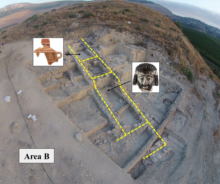
The 9thcentury building, possibly a citadel similar to one from Hazor, produced a beautifully decorated Phoenician Bichrome jar and the now famous faience head of a bearded man (which will be the subject of a piece in ANEToday next week by Naama Yahalom-Mack).
Area B looking northwest. The yellow lines help identify the main walls of the structure, possibly a citadel, that extended to the south. The eastern closing wall is clearly visible. Two of the rooms produced significant finds–a Phoenician Bichrome Jar and the faience head of a bearded Levantine male. Image courtesy of the authors.
14Carbon samples, as well as the pottery, indicate that this building ended sometime in the 9th century BCE, a finding that might support William Schniedewind’s reconstruction of “Abel” at the end of line 2 on the Tel Dan Inscription. But if this building was destroyed in the 9th century, then where is the 8thcentury city destroyed by Tiglath-Pileser III (2 Kings 15:29)? No stratified remains from this period have been found so far, even though 8thcentury sherds occasionally appear in our pottery buckets.
After six seasons of excavation, there is still much that we need to learn. Yet, every new season produces more pieces to the puzzle of this fascinating and productive site.
Robert Mullins, Naama Yahalom-Mack, and Nava Panitz-Cohen are the co-directors of the Tell Abel Beth Maacah excavations.
How to cite this article:
Mullins, R. et al. 2019. “Northern Exposure: Tel Abel Beth Maacah after Six Seasons of Excavation“, The Ancient Near East Today 7.1. Accessed at: https://anetoday.org/northern-abelbethmaacah-excavation/.

Post a comment