Sinai’s Century: The Photographs of the Library of Congress
September 2019 | Vol. 7.9
By Ahmed Shams
The Sinai Peninsula is perennially caught between extremes. Sometimes wide open for visitors and other times restricted by authorities and events, it is also at once eternally unchanged and increasingly urbanised. Photographs are one way to capture the contradictions.
The Prints and Photographs Online Catalog (PPOC) of the Library of Congress (LoC) holds one of the most comprehensive photographic collections of the peninsula. A recent project with LoC’s Prints and Photographs Catalog, inspired by the 19-year survey of Sinai Peninsula Research (SPR), brings to life the landscapes as never before.
The SPR survey traversed the land over many years to transfer undocumented local knowledge onto maps. SPR’s cross-disciplinary research used direct oral communication with local Bedouins to recover hundreds of place names for remote local areas, mountains, valleys, water points, and more, which had never before made their way to maps or geographic accounts via individual scholars, research institutions or survey authorities. The SPR survey resulted in a database of more than14,000 undocumented and published records for Sinai Peninsula, identified by place names or coded items.
The SPR field notes, survey maps, publications, single and panoramic landscape photographs, and names of physical and cultural features, are the source of the detailed geography description for each of the more than 500 photographic entries for Sinai contained in the Prints and Photographs Online Catalog. The wider database also acts as the foundation for the detailed descriptions of each entry, including notes on archaeology, anthropology and ecology.
The traditional route of the Exodus route across the peninsula, Mount Sinai and the Monastery of St. Catherine, dominated the imagination of Western travellers by the end 19thcentury. The LoC’s archive is primarily formed from five black and white landscape photographic collections in which these locations are prominently featured.
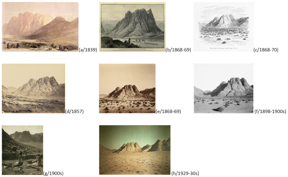
Traditional location of
Biblical
Mount Horeb or Ras El Sefsafa
(
Arabic:
the mountain of the willow tree
), one of the
twenty plus repetitive sceneries
across the mountain range
: (a) David Roberts; (b) Charles Wilson (OS
Sinai); (c) Edward Palmer (OS Sinai); (d) Francis Frith; (e) J. McDonald in
1868-69 (OS Sinai); (f) John Whiting & others (American Colony of
Jerusalem); (g) Underwood & Underwood; (h) Frédéric Boissonnas
These collections are:
‘Sinai and Palestine,’ Photographed by Francis Frith in 1857 and published by William MacKenzie & Co. in London in 1863;
The Ordnance Survey of the Peninsula of Sinai by J. McDonald in 1868-1869, and publishedin Southampton by the Ordnance Survey Office in 1869 for the Palestine Exploration Fund;
The Photograph Department of the American Colony of Jerusalem by John Whiting and others, and published by Eric and Edith Matson Negatives in Jerusalem between 1898 and 1946, (and colorized between 1950-1977);
Bernhard Moritz in 1910 and published by Dietrich Riemer in Berlin in 1916;
Underwood & Underwood stereoscopic photographs in early 20th century, published by Elmer and Bert Elias in New York in 1913
Matson’s photographs form the bulk of the LoC’s holdings for the peninsula, in addition to Moritz and few entries from Frith and Underwood & Underwood. The LoC-SPR Project added geographic and historic information to all these collections. All painters and photographers followed the same repetitive geographical pattern as pilgrims, travellers, scholars and tourists (overall capturing more than twenty repetitive sceneries and their neighbouring landscapes), with offshoots to remote areas along the caravan routes to Mount Sinai. This repetition has allowed information to be added to many similar photographs.
Eric Matson gave the American Colony collection to the Library of Congress in 1960s and 1970s, and he helped the Library’s staff to attribute the photographs. Most photographs weregiven generic place names or descriptive subject names, to identify the main physical or cultural features or human aspects captured in each.
Biblical Mount Sinai and Wadi El Dier (Holy Valley) of the Monastery of Saint Catherine were among the most popular subjects, and they appear to have remained frozen in time, even in the 21st century. As the English traveller Frederick Hennicker put it in 1824, “….all the rest is a sea of desolation. It would seem as if Arabia Petra had once been an ocean of lava, and that while its waves were running literally mountains high, it was commanded suddenly to stand still.”
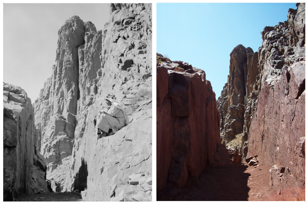
Siqqat Abbas Basha
to the summit of Mount Sinai (Biblical Sinai)
―
Abbas Helmi I, the Khedive of Egypt (1849-54) who visited and paved
several paths in the vicinity of Mount Sinai and along the pilgrimage routes
in Sinai Peninsula in 1853-54 CE: (a) 1920s-early 1930s CE by ACJ, (b) 16
September 2013 CE by SPR, Library of Congress, Prints & Photographs
Division, LC-DIG-matpc-1557
Fash and chapel (Grotto) of Elijah (Elias) part of
Siqqat Sydina Musa, the
Byzantine monastic and pilgrimage 3,750 rock steps path (4th-7th centuries
CE) from the Monastery of Saint Catherine to the summit of Mount Sinai
(Biblical Sinai): (a) 1920s-eraly 1930s CE by ACJ, (b) 30 July 2015 CE by
SPR, Library of Congress, Prints & Photographs Division, LC-DIG-matpc-
15578
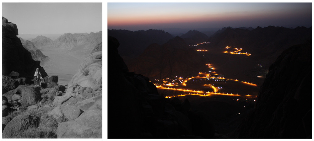
In contrast, one of the most remarkable changes in the landscape has been the emergence of the Town of Katharina (Saint Catherine) and a cluster of Bedouin villages around Mount Sinai and the Monastery of Saint Catherine since the late 1970s. This period marked the transition of local Bedouin economy from subsistence (herding, mountainous agriculture, charcoal production, and wage labour) to mass tourism and its associated traditional productssuch as handicrafts, and medicinal plants.
Town of Katharina (Saint Catherine) in El Melga Plain and cone-shape
summit of Mount Sinai (Biblical Sinai or Gebel Musa) from the ruins of the mountain palace (Qasr) of Abbas Helmi I, the Khedive of Egypt (1849-54)
who visited the peninsula in 1853-54 CE: (a) 1910-20 CE by Underwood &
Underwood, (b) 13-14 August 2015 CE by SPR, Library of Congress, Prints
& Photographs Division, LC-DIG-ppmsca-05050
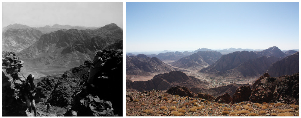
El Raha Plain the traditional encampment of the Israelites at the foot of
Biblical Mount Horeb and the lights of the hotels area of the Town of
Katharina and distant lights of the Bedouin villages of El
A'gramiya and
Abu Sila, from the summit of Ras El Sefsafa (Monacha, Mount Horeb): (a)
1900-20 CE by ACJ, (b) 29 July 2015 CE by SPR, Library of Congress,
Prints & Photographs Division, LC-DIG-matpc-02078
Mass tourism encouraged the Gebaliya Bedouins to settle in the vicinity of Mount Sinai for relatively stable incomes, but it came with an environmental price. The approximately 7,000 inhabitants put pressure on ground water resources, beside sanitation problems. Moreover, expanding remote mountain orchards and pastures and herding on the mountain slopes and valleys surrounding the new localities has led to increased ground water and vegetation exploitation and demand for water transfer from remote valleys.
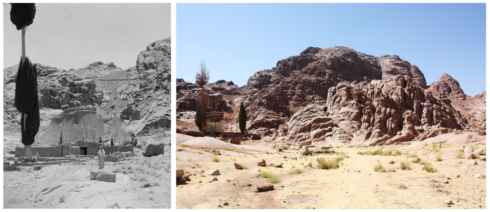
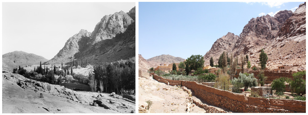
With longer droughts by the end of 20th and early 21st centuries compared to the accounts and records from late 19th and the first half of 20th century, Wadi El Dier (Holy Valley) and the orchard of the Monastery of Saint Catherine suffered from low rain and snow rates and runoff of surface water. This led to a drop in ground water levels, less dense orchards and a growing need to transfer or channel water from surrounding valleys. The difference in the density of trees in the monastery’s orchard is clear in older and newer photographs.
The Byzantine fortress of the Monastery of Saint Catherine and its
orchard (6th century CE) and Gebel Muneiga in Wadi El Dier (Biblical Holy
Valley): (a) 1898-1914 CE by ACJ, (b) 16 August 2015 CE by SPR, Library
of Congress, Prints & Photographs Division, LC-DIG-matpc-07251
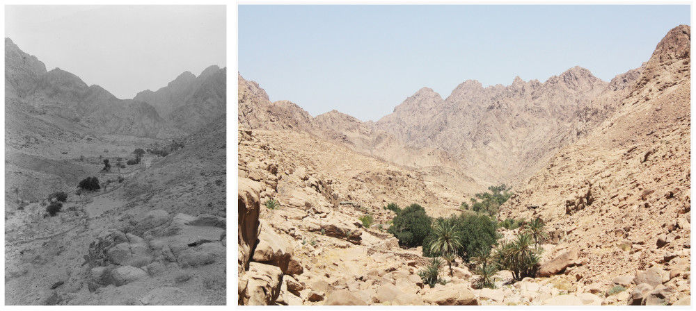
But the opposite is true when it comes to other well-watered valleys. Wadi Tilah (Rudhwah) is part of the downstream area of a major watershed in the northern half of the mountain range, the High Mountains of Sinai Peninsula. Its close proximity to the Town of Katharina led to intensified mountainous orchard construction by the end of the 20th century. The Bedouins reused considerable number of the ruined Byzantine buildings, retaining walls, andwater harvesting structures across the mountain range, such as water dams and wells, reservoirs & cisterns and conduits.
The orchards and palm groves of Wadi Tilah (Rudhwah) and the twin-
summit of Gebel Hagig: (a) 1900-20 CE by ACJ, (b) 08 August 2015 CE by
SPR, Library of Congress, Prints & Photographs Division, LC-DIG-matpc-
02090
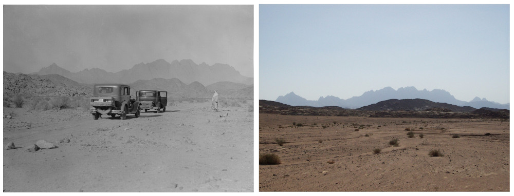
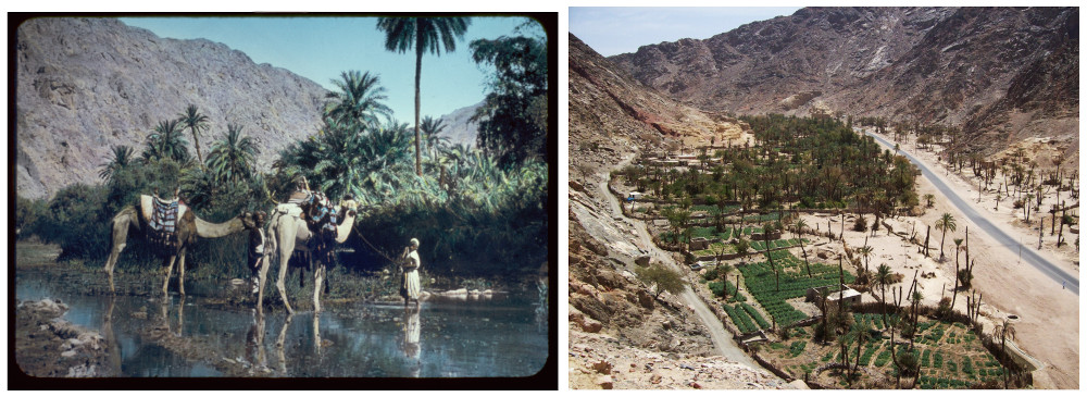
The upland caravan route (Way of Petra or the traditional Exodus Route) winds from the Gulf of Suez to Mount Sinai (Gebel Musa) at the heart of the High Mountains of Sinai Peninsula, via the dense palm groves of the oasis of Wadi Feiran (Biblical Rephidim) at the foot of Mount Serbal, once thought to be the true location of Mount Sinai. The first dirt road was constructed by the British Frontier Districts Administration in the 1920s, when motor vehicles started replacing camels, and was asphalted during the 1980s.
The dirt-road of Wadi El Sheikh, the crown-shape summit of Gebel Serbal
and the triangle-shape summit of Gebel Serbal Umm Takha
:
(a) 1925-46 CE by ACJ, (b) 21 September 2013 CE by SPR, Library of Congress, Prints &
Photographs Division, LC-DIG-matpc-13509
The palm grove of the oasis of Wadi Feiran (Biblical Rephidim) at the
foot of Mount Serbal
:
(a) originally captured in 1900-20 by ACJ and colored
in 1950-77 CE, (b) 23 April 2009 CE by SPR, Library of Congress, Prints &
Photographs Division, LC-DIG-matpc-23011
Despite the rise of modern economies, enhanced accessibility, internal migration, emergenceof new settlements and the pressure on natural resources such as water and vegetation, the revival of the mapping and mapmaking and documentation practices of the 19th century by Sinai Peninsula Research (SPR) allowed the detailed attribution of mid-19th/early 20th centuries photographs in the 21st century.
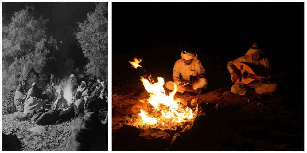
The traditional patterns of Bedouin mountain knowledge-making have changed and so has the cultural landscape. In a sense, technology has reached the campfire, with the capacity to enrich, alter or replace a knowledge base that is still far from fully documented. This knowledge is also the key to better understanding the ever-developing patterns of resource use and human interaction.
Bedouin campfire yesterday and today
:
(a) 1900-20 CE by ACJ, (b) 31
July 2015 CE by SPR, Library of Congress, Prints & Photographs Division,
LC-DIG-matpc-02112
Acknowledgment: I would like to thank Arden Alexander, Cataloger at the Prints and Photographs Division at the Library of Congress, for his tireless effort to update the Sinai’s 500 plus online photographic entries with notes for each by SPR.
Ahmed Shams teaches in MA International Cultural Heritage Management (ICHM) at Durham University and is a research consultant at the School of Archaeology, University of Oxford (Endangered Archaeology in the Middle East and North Africa ― EAMENA project), and is a fellow of the Royal Geographical Society (RGS). Dr Shams is the founder of Sinai Peninsula Research (SPR).
How to cite this article:
Shams, A. 2019. “Sinai’s Century: The Photographs of the Library of Congress”, The Ancient Near East Today 7.9. Accessed at: https://anetoday.org/sinai-congress-library/.

Post a comment